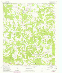
1960 Map of Thomas
USGS Topo · Published 1980About this map
Little Cypress Creek and its many tributaries, including Prairie Creek and Enon Branch, weave through this rural landscape in Upshur County. The map reveals a community structured around small settlements and centers of worship, such as Thomas, Enon, and Grice. These locales are often anchored by family and community landmarks like Soules Chapel, Antioch Ch, and the Midway Crossroads Ch. Educational and cemetery sites provide significant value for those tracing local lineages, with Harmony Sch and the Simpsonville Cem situated among the winding creek beds.
Find a feature on this map
30 named features on this map. Tap any name to fly to it.
Don’t see what you’re looking for? This feature index may not catch every label — zoom into the map to look around manually.
Map Details
Editions of this 1960 Thomas Map
3 editions found
Other maps of this area

1956 · Tyler
USGS Topo · 1:250,000

1960 · Shady Grove
USGS Topo · 1:24,000

1960 · Pritchett
USGS Topo · 1:24,000

1960 · Bettie
USGS Topo · 1:24,000

1960 · Gilmer
USGS Topo · 1:24,000

1960 · Thomas
USGS Topo · 1:24,000

1960 · Newsome
USGS Topo · 1:24,000

1960 · Leesburg
USGS Topo · 1:24,000

1960 · Rhonesboro
USGS Topo · 1:24,000

1960 · Pittsburg
USGS Topo · 1:24,000