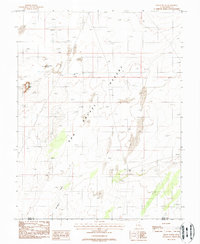
1988 Map of Gilson Butte
USGS Topo · Published 1988About this map
San Rafael Desert dominates this arid landscape, a region defined by high-elevation plateaus and isolated water sources. Published in the late 1980s, the survey captures the vastness of the terrain where Gilson Butte and Little Gilson Butte serve as prominent navigation landmarks. The scarcity of surface water is reflected in the mapping of deep-earth infrastructure such as Gilson Butte Well and Jeffery Well, which are critical nodes for any human activity in this corner of Emery and Wayne Counties.
Find a feature on this map
9 named features on this map. Tap any name to fly to it.
Don’t see what you’re looking for? This feature index may not catch every label — zoom into the map to look around manually.
Map Details
Editions of this 1988 Gilson Butte Map
This is the sole edition of this map. No revisions or reprints were ever made.
Other maps of this area

1885 · San Rafael
USGS Topo · 1:250,000

1953 · Tidwell 3 NW
USGS Topo · 1:24,000

1953 · Temple Mtn
USGS Topo · 1:62,500

1954 · Stinking Springs Creek 4 SW
USGS Topo · 1:24,000

1954 · Stinking Spring Creek 4 NE
USGS Topo · 1:24,000

1954 · Stinking Spring Creek 4 NW
USGS Topo · 1:24,000

1954 · Stinking Spring Creek 4 SE
USGS Topo · 1:24,000

1954 · Mt. Ellen 1 NW
USGS Topo · 1:24,000

1956 · Salina
USGS Topo · 1:250,000

1960 · Salina
USGS Topo · 1:250,000