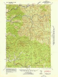
1942 Map of Ginger Peak
USGS Topo · Published 1942About this map
The Siuslaw National Forest dominates this topographic survey, revealing the remote timberlands of the Northern Oregon Coast Range during the early 1940s. The landscape is defined by the complex drainage systems of the Trask River and the Nestucca River, with numerous tributaries such as Killam Creek and East Fork Trask River carving through the steep terrain. Human activity is largely concentrated along the river valleys and the Wilson River Highway, which provided a critical transportation link through the mountains.
Find a feature on this map
39 named features on this map. Tap any name to fly to it.
Don’t see what you’re looking for? This feature index may not catch every label — zoom into the map to look around manually.
Map Details
Editions of this 1942 Ginger Peak Map
2 editions found
Other maps of this area

1937 · Nehalem
USGS Topo · 1:62,500

1937 · Enright
USGS Topo · 1:62,500

1941 · Nestucca Bay
USGS Topo · 1:62,500

1941 · Timber
USGS Topo · 1:62,500

1941 · Enright
USGS Topo · 1:62,500

1942 · Ginger Peak
USGS Topo · 1:62,500

1942 · Sheridan
USGS Topo · 1:62,500

1942 · Spirit Mtn
USGS Topo · 1:62,500

1942 · Nestucca Bay
USGS Topo · 1:62,500

1942 · Fairdale
USGS Topo · 1:62,500