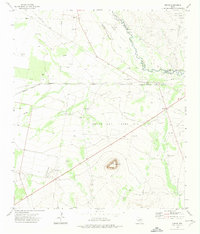
1972 Map of Girvin
USGS Topo · Published 1975About this map
The Pecos River carves a winding path along the border of Crane and Crockett counties, defining a landscape shaped by petroleum extraction and ranching in the early 1970s. This desert environment is dominated by industrial infrastructure, where the Brown and Thorp Oil Field and the Wentz Oil and Gas Field are crisscrossed by an extensive network of pipelines and drill holes. The settlement of Girvin serves as a small hub along the Atchison Topeka and Santa Fe railroad, characterized by the nearby Girvin Cem and a remote Landing Strip to the south.
Find a feature on this map
16 named features on this map. Tap any name to fly to it.
Don’t see what you’re looking for? This feature index may not catch every label — zoom into the map to look around manually.
Map Details
Editions of this 1972 Girvin Map
This is the sole edition of this map. No revisions or reprints were ever made.
Other maps of this area

1928 · Crane
USGS Topo · 1:125,000

1928 · Comanche Spring
USGS Topo · 1:125,000

1929 · Independence Draw Quadrangle
USGS Topo · 1:125,000

1954 · Pecos
USGS Topo · 1:250,000

1954 · Fort Stockton
USGS Topo · 1:250,000

1957 · Pecos
USGS Topo · 1:250,000

1958 · Fort Stockton
USGS Topo · 1:250,000

1969 · Bootleg Canyon
USGS Topo · 1:24,000

1969 · Bakersfield
USGS Topo · 1:24,000
1970 · Saddle Butte
USGS Topo · 1:24,000