
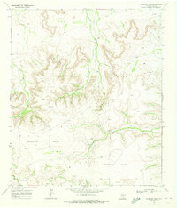
1969 Map of Bootleg Canyon
USGS Topo · Published 1972About this map
Wentz Oil and Gas Field dominates the high plains in this late 1960s survey of Pecos County, illustrating a landscape defined by petroleum extraction. The map is densely marked with infrastructure including numerous Gas Wells, Oil Wells, and several Drill Holes that pierce the plateau. Amidst this industrial activity, the cattle-ranching legacy of west Texas persists at family-owned outposts like the Louis Woodward Ranch, Fannie Woodward Ranch, and the Baker Ranch near the southern boundary.
Find a feature on this map
15 named features on this map. Tap any name to fly to it.
Don’t see what you’re looking for? This feature index may not catch every label — zoom into the map to look around manually.
Map Details
Editions of this 1969 Bootleg Canyon Map
This is the sole edition of this map. No revisions or reprints were ever made.
Other maps of this area

1928 · Crane
USGS Topo · 1:125,000

1928 · Comanche Spring
USGS Topo · 1:125,000

1929 · Independence Draw Quadrangle
USGS Topo · 1:125,000

1954 · Pecos
USGS Topo · 1:250,000

1954 · Fort Stockton
USGS Topo · 1:250,000

1957 · Pecos
USGS Topo · 1:250,000

1958 · Fort Stockton
USGS Topo · 1:250,000

1969 · Skyscraper Peak
USGS Topo · 1:24,000

1969 · Bakersfield
USGS Topo · 1:24,000
1969 · Sherbino Mesa
USGS Topo · 1:24,000