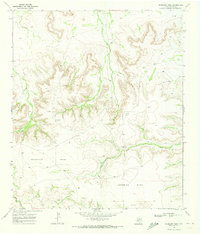
1969 Map of Sherbino Mesa
USGS Topo · Published 1973About this map
Sherbino Mesa and McKenzie Mesa dominate this West Texas landscape, defined by high tablelands and the deeply carved drainages of Fourmile Draw and Harral Draw. This 1969 field-checked survey documents a transition from traditional ranching to modern energy exploration in Pecos County. While ranching outposts like Ligon Ranch and Harrelson Ranch remain as primary human markers on the land, the map is heavily peppered with evidence of geological prospecting. Numerous entries for a Drill Hole and an Oil Well reveal the intensive sub-surface investigation of the era. The presence of a prominent Tower and intricate fence lines, indicated by fine red dashed lines, illustrates how the vast open range was increasingly managed and segmented during the late 1960s.
Find a feature on this map
9 named features on this map. Tap any name to fly to it.
Don’t see what you’re looking for? This feature index may not catch every label — zoom into the map to look around manually.
Map Details
Editions of this 1969 Sherbino Mesa Map
This is the sole edition of this map. No revisions or reprints were ever made.
Other maps of this area

1929 · Independence Draw Quadrangle
USGS Topo · 1:125,000

1954 · Fort Stockton
USGS Topo · 1:250,000

1958 · Fort Stockton
USGS Topo · 1:250,000

1969 · Bootleg Canyon
USGS Topo · 1:24,000

1969 · Skyscraper Peak
USGS Topo · 1:24,000

1969 · Hackberry Draw NW
USGS Topo · 1:24,000

1969 · Hackberry Draw NE
USGS Topo · 1:24,000
1969 · Hat-A Ranch
USGS Topo · 1:24,000

1969 · Indian Mesa
USGS Topo · 1:24,000

1969 · Bakersfield
USGS Topo · 1:24,000