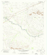
1972 Map of Girvin SE
USGS Topo · Published 1975About this map
The Pecos River serves as a winding natural boundary through this West Texas landscape, marking the division between Crockett and Pecos counties. By the early 1970s, the terrain was heavily defined by energy extraction and transit, with the Crossett Oil Field, El Cinco Oil Field, and Wentz Oil and Gas Field blanketing the plains with a network of pipelines and service roads. To the north, the Atchison Topeka and Santa Fe railroad runs parallel to the highway, connecting these remote production zones to larger regional hubs.
Find a feature on this map
21 named features on this map. Tap any name to fly to it.
Don’t see what you’re looking for? This feature index may not catch every label — zoom into the map to look around manually.
Map Details
Editions of this 1972 Girvin SE Map
This is the sole edition of this map. No revisions or reprints were ever made.
Other maps of this area

1928 · Crane
USGS Topo · 1:125,000

1929 · Independence Draw Quadrangle
USGS Topo · 1:125,000

1954 · Pecos
USGS Topo · 1:250,000

1954 · Fort Stockton
USGS Topo · 1:250,000

1957 · Pecos
USGS Topo · 1:250,000

1958 · Fort Stockton
USGS Topo · 1:250,000

1969 · Bootleg Canyon
USGS Topo · 1:24,000

1969 · Indian Mesa
USGS Topo · 1:24,000

1969 · Bakersfield
USGS Topo · 1:24,000

1972 · Girvin NE
USGS Topo · 1:24,000