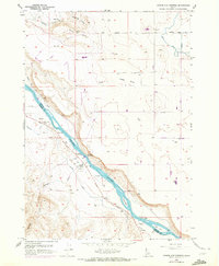
1958 Map of Givens Hot Springs
USGS Topo · Published 1972About this map
Givens Hot Springs is the focal point of this riverine survey, situated along the Snake River at the boundary of Canyon and Owyhee counties. The map highlights the archaeological and historical depth of the area, featuring the Map Rock (Petroglyphs) and the former locations of the Hot Springs Ferry and Bernard Ferry. This landscape is defined by the transition from the basaltic prominence of Pickles Butte and Deadhorse Canyon to the irrigated lowlands of Hidden Valley. The sophisticated water management of the mid-20th century is evident through a network of infrastructure including the Mora Canal, Opalene Ditch, and several flumes and pumps. These systems divert water from the river to support agriculture in the surrounding arid terrain, while islands such as Rippee Island and Ware Island divide the river's course.
Find a feature on this map
33 named features on this map. Tap any name to fly to it.
Don’t see what you’re looking for? This feature index may not catch every label — zoom into the map to look around manually.
Map Details
Editions of this 1958 Givens Hot Springs Map
2 editions found
Other maps of this area

1892 · Silver City
USGS Topo · 1:125,000

1894 · Silver City
USGS Topo · 1:125,000

1898 · Nampa
USGS Topo · 1:125,000

1898 · Silver City
USGS Topo · 1:125,000

1955 · Boise
USGS Topo · 1:250,000
1957 · Walters Butte
USGS Topo · 1:24,000

1957 · Opalene Gulch
USGS Topo · 1:24,000

1957 · Wilson Peak
USGS Topo · 1:24,000

1957 · Sands Basin
USGS Topo · 1:62,500

1958 · Boise
USGS Topo · 1:250,000