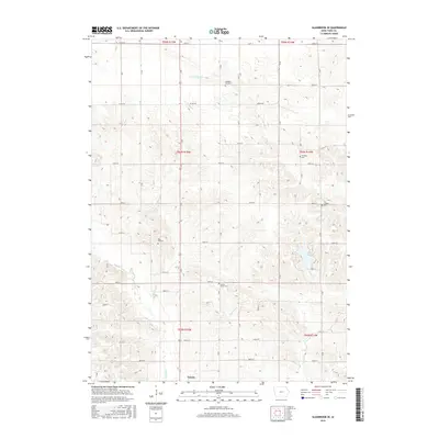
2015 Map of Gladbrook SE
USGS Topo · Published 2015About this map
Toledo anchors the southern edge of this agricultural landscape in Tama County, where the terrain is defined by the branching drainages of Salt Cr and Otter Cr. The map reveals a dense network of rural infrastructure, including several family and community burial grounds such as Wheaton Cem, Pleasant Hill Cem, and the County Home Cem. These small, localized landmarks are essential for genealogical research, often marking the early centers of settlement before the consolidation of rural communities.
Find a feature on this map
42 named features on this map. Tap any name to fly to it.
Don’t see what you’re looking for? This feature index may not catch every label — zoom into the map to look around manually.
Map Details
Editions of this 2015 Gladbrook SE Map
This is the sole edition of this map. No revisions or reprints were ever made.
Other maps of this area

1954 · Waterloo
USGS Topo · 1:250,000

1954 · Des Moines
USGS Topo · 1:250,000

1955 · Waterloo
USGS Topo · 1:250,000

1956 · Des Moines
USGS Topo · 1:250,000

1957 · Des Moines
USGS Topo · 1:250,000

1968 · Chelsea
USGS Topo · 1:24,000

1969 · Des Moines
USGS Topo · 1:250,000

1971 · Gladbrook NE
USGS Topo · 1:24,000

1971 · Traer
USGS Topo · 1:24,000
1971 · Clutier
USGS Topo · 1:24,000