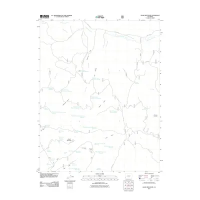
2011 Map of Glade Mountain
USGS Topo · Published 2011About this map
Glade Mountain and Thomas Mountain anchor this high-elevation landscape in Dolores County, where a complex network of water management features reveals the critical role of irrigation and storage in the American West. The map shows a series of numbered reservoirs along Disappointment Creek and its tributaries, including Disappointment Number Nine Reservoir and Disappointment Number Two Reservoir, indicating a highly organized system of water rights and land use. This infrastructure supports the surrounding terrain of The Glade and The Hogback. Resource extraction is evidenced by the Broken Thumb Mine near the center of the sheet, while navigational aids like Benchmark Lookout serve as vital points in this remote terrain. Numerous springs and draws, such as Bradfield Spring and McKinney Draw, feed the network of basins that define the local ranching or agricultural economy of the early 21st century.
Find a feature on this map
50 named features on this map. Tap any name to fly to it.
Don’t see what you’re looking for? This feature index may not catch every label — zoom into the map to look around manually.
Map Details
Editions of this 2011 Glade Mountain Map
This is the sole edition of this map. No revisions or reprints were ever made.
Other maps of this area

1956 · Cortez
USGS Topo · 1:250,000

1958 · Cortez
USGS Topo · 1:250,000

1959 · Cortez
USGS Topo · 1:250,000

1962 · Cortez
USGS Topo · 1:250,000
1964 · Dawson Draw
USGS Topo · 1:24,000

1964 · Glade Mountain
USGS Topo · 1:24,000
1964 · North Mountain
USGS Topo · 1:24,000

1964 · Mc Kenna Peak
USGS Topo · 1:24,000

1964 · The Glade
USGS Topo · 1:24,000
1964 · South Mountain
USGS Topo · 1:24,000