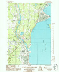
1985 Map of Gladstone
USGS Topo · Published 1985About this map
Escanaba and Gladstone dominate the western shoreline of Little Bay de Noc in this mid-1980s coastal study. The landscape is defined by the industrial and transport infrastructure of the Upper Peninsula, where the Chicago and North Western railway lines parallel the coast, connecting the northern settlement of Kipling down through Wells and into the city centers. Significant industrial footprints are evident, including multiple stone quarries, a lime stone quarry, and the extensive industrial waste ponds near Groos.
Find a feature on this map
49 named features on this map. Tap any name to fly to it.
Don’t see what you’re looking for? This feature index may not catch every label — zoom into the map to look around manually.
Map Details
Editions of this 1985 Gladstone Map
This is the sole edition of this map. No revisions or reprints were ever made.
Other maps of this area

1932 · Gladstone NE
USGS Topo · 1:31,680

1932 · Gladstone SE
USGS Topo · 1:31,680

1932 · Rapid River NW
USGS Topo · 1:31,680

1932 · Rapid River SW
USGS Topo · 1:31,680

1932 · Gladstone SW
USGS Topo · 1:31,680

1932 · Gladstone NW
USGS Topo · 1:31,680

1950 · Gladstone NW
USGS Topo · 1:31,680

1954 · Escanaba
USGS Topo · 1:250,000

1957 · Escanaba
USGS Topo · 1:250,000

1958 · Escanaba
USGS Topo · 1:250,000