
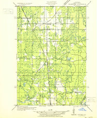
1932 Map of Gladstone NE
USGS Topo · Published 1932About this map
The Chicago and Northwestern railroad corridor dictates the settlement pattern of this 1930s Upper Peninsula landscape, connecting the hamlets of Beaver, Perkins, Winde, and Brampton. This rail-oriented development is further reinforced by State Highway No 35, which runs north-south through the center of the survey. The terrain is defined by the drainage basins of the Tacoosh River, Days River, and Whitefish (Branch), flowing toward the southern edge of the map where the Escanaba River meets Little Bay De Noc. Local community life is evidenced by the distribution of rural institutions like Youngs School, Days River School, and St Josephs Cem, alongside logging-era traces like Johnson Camp in the northern timberlands. This map captures the transition from an early resource-extraction economy to a more established network of small roadside and trackside communities.
Find a feature on this map
29 named features on this map. Tap any name to fly to it.
Don’t see what you’re looking for? This feature index may not catch every label — zoom into the map to look around manually.
Map Details
Editions of this 1932 Gladstone NE Map
2 editions found
Other maps of this area

1932 · Rock SW
USGS Topo · 1:31,680

1932 · Trenary SW
USGS Topo · 1:31,680

1932 · Gladstone SE
USGS Topo · 1:31,680

1932 · Rapid River NW
USGS Topo · 1:31,680

1932 · Rock SE
USGS Topo · 1:31,680

1932 · Rapid River SW
USGS Topo · 1:31,680

1932 · Gladstone SW
USGS Topo · 1:31,680

1932 · Gladstone NW
USGS Topo · 1:31,680

1950 · Gladstone NW
USGS Topo · 1:31,680

1954 · Escanaba
USGS Topo · 1:250,000