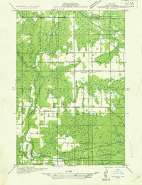
1932 Map of Gladstone SW
USGS Topo · Published 1932About this map
Ford River snakes through the dense woodland and wetlands of the Escanaba River State Forest, defining the rural character of Delta County during the early 1930s. The settlement pattern here is anchored by small community nodes such as Flatrock, where Holy Family Ch stands, and several rural schoolhouses like Sovey Sch, Howard Sch, and Nadon Sch that served the outlying families. Transportation is dominated by two major rail lines, the Chicago and Northwestern and the Minneapolis St Paul and Sault Ste Marie, which intersect at Portage. These tracks provided the primary industrial link for local timber and agricultural goods. To the west, the tiny stop of Newhall sits along the riverbank, reflecting the era's reliance on rail and water for local commerce and connectivity across the Upper Peninsula.
Find a feature on this map
18 named features on this map. Tap any name to fly to it.
Don’t see what you’re looking for? This feature index may not catch every label — zoom into the map to look around manually.
Map Details
Editions of this 1932 Gladstone SW Map
2 editions found
Other maps of this area

1932 · Gladstone NE
USGS Topo · 1:31,680

1932 · Gladstone SE
USGS Topo · 1:31,680

1932 · Bark River NE
USGS Topo · 1:31,680

1932 · Whitney NE
USGS Topo · 1:31,680

1932 · Whitney SE
USGS Topo · 1:31,680

1932 · Gladstone SW
USGS Topo · 1:31,680

1932 · Gladstone NW
USGS Topo · 1:31,680

1950 · Gladstone NW
USGS Topo · 1:31,680

1954 · Escanaba
USGS Topo · 1:250,000

1957 · Escanaba
USGS Topo · 1:250,000