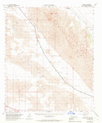
1955 Map of Glamis
USGS Topo · Published 1966About this map
Coachella Canal cuts a distinctive diagonal across this mid-century landscape, marking a vital water artery through the arid Imperial County terrain. This survey reflects a period of significant water management and military presence, as the canal corridor parallels the Southern Pacific railroad line near the settlements of Glamis and Ruthven. The map highlights the stark transition from the East Mesa and its Sand Dunes to the rising elevations of the Chocolate Mountains, featuring Deer Peak. Military land use is well-documented via the US Naval Reservation, which includes a Landing Strip and various Jeep Trail networks. Infrastructure such as Coachella Bridge No 1 and Coachella Bridge No 2, alongside a Gaging Sta, provides evidence of the engineering required to sustain travel and irrigation in this desert environment.
Find a feature on this map
16 named features on this map. Tap any name to fly to it.
Don’t see what you’re looking for? This feature index may not catch every label — zoom into the map to look around manually.
Map Details
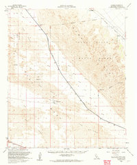
Editions of this 1955 Glamis Map
2 editions found
Other maps of this area

1903 · Yuma
USGS Topo · 1:125,000

1905 · Yuma
USGS Topo · 1:125,000

1907 · Holtville
USGS Topo · 1:125,000

1940 · Iris
USGS Topo · 1:62,500

1940 · Alamorio
USGS Topo · 1:62,500

1940 · Calexico
USGS Topo · 1:62,500

1942 · El Centro
USGS Topo · 1:250,000

1942 · Yuma
USGS Topo · 1:250,000

1942 · Blythe
USGS Topo · 1:250,000

1943 · Calexico
USGS Topo · 1:62,500