
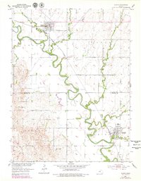
1952 Map of Glasco
USGS Topo · Published 1954About this map
The Solomon River meanders across the Kansas plains in this early 1950s survey, marking the transition between Cloud Co and Ottawa Co. The town of Glasco serves as a northern hub, where new infrastructure is visible via a section marked under construction at the town's edge. Further south, the town of Delphos is positioned near the banks of Henry Creek and the Union Pacific rail line. The landscape is defined by the river’s complex oxbows and a network of named tributaries including Fisher Creek and Mortimer Creek. Local landmarks like the Landing Field and the Pumping Station reflect the mid-century utility of the region, while the St Paul Cem offers a point of interest for those researching family history in the southern portion of the quadrangle.
Find a feature on this map
20 named features on this map. Tap any name to fly to it.
Don’t see what you’re looking for? This feature index may not catch every label — zoom into the map to look around manually.
Map Details
Editions of this 1952 Glasco Map
2 editions found
Other maps of this area

1892 · Minneapolis
USGS Topo · 1:125,000

1952 · Glasco SW
USGS Topo · 1:24,000

1953 · Glasco NE
USGS Topo · 1:24,000

1953 · Simpson
USGS Topo · 1:24,000

1955 · Manhattan
USGS Topo · 1:250,000

1956 · Manhattan
USGS Topo · 1:250,000

1957 · Manhattan
USGS Topo · 1:250,000

1961 · Tescott NE
USGS Topo · 1:24,000
1964 · Ada
USGS Topo · 1:24,000

1965 · Minneapolis North
USGS Topo · 1:24,000