
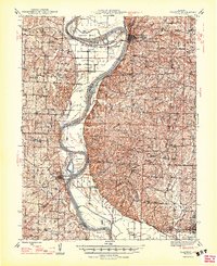
1947 Map of Glasgow
USGS Topo · Published 1947About this map
The Missouri River dictates the landscape of this mid-1940s survey, winding through a complex series of bends and chutes at the borders of Saline, Howard, and Cooper counties. The river\'s shifting course is evident in features like the Old Channel near Petersburg and the broad curves of Glasgow Bend and Euphrasie Bend. The settlement of Glasgow serves as a primary hub where the Alton railroad crosses the water, while downstream, the river passes the historic town of Arrow Rock and its adjacent Arrow Rock State Park.
Find a feature on this map
92 named features on this map. Tap any name to fly to it.
Don’t see what you’re looking for? This feature index may not catch every label — zoom into the map to look around manually.
Map Details
Editions of this 1947 Glasgow Map
2 editions found
Other maps of this area

1887 · Sedalia
USGS Topo · 1:125,000

1888 · Boonville
USGS Topo · 1:125,000

1890 · Glasgow
USGS Topo · 1:125,000

1890 · Marshall
USGS Topo · 1:125,000

1892 · Marshall
USGS Topo · 1:125,000

1894 · Sedalia
USGS Topo · 1:125,000

1901 · Marshall
USGS Topo · 1:125,000

1940 · Marshall
USGS Topo · 1:62,500

1944 · Marshall
USGS Topo · 1:62,500

1947 · Jefferson City
USGS Topo · 1:250,000