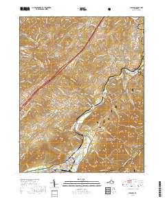
2019 Map of Glasgow
USGS Topo · Published 2019About this map
The confluence of the James River and the Maury River anchors this detailed study of the Virginia landscape, where the town of Glasgow serves as a central hub. Rising above the riverbanks, Sallings Mountain and Brady Mountain frame a region defined by its deep Appalachian roots and family-named landmarks. Genealogists will find significant value in the mapped locations of the Salling Family Cem, Paxton Cem, and Falling Spring Cem, which are tucked away near settlements like Buffalo Forge and Mechanicsville. The rugged eastern portion of the sheet is dominated by the George Washington National Forest and the Jefferson National Forest, with the Appalachian National Scenic Trail winding across the high ridges through Saddle Gap. Modern infrastructure such as the B G Locher Bridge at Balcony Falls marks the ongoing evolution of these historic river crossings.
Find a feature on this map
122 named features on this map. Tap any name to fly to it.
Don’t see what you’re looking for? This feature index may not catch every label — zoom into the map to look around manually.
Map Details
Editions of this 2019 Glasgow Map
This is the sole edition of this map. No revisions or reprints were ever made.
Other maps of this area

1894 · Natural Bridge
USGS Topo · 1:125,000

1894 · Lexington
USGS Topo · 1:125,000

1894 · Natural Bridge
USGS Topo · 1:62,500

1907 · Natural Bridge Special
USGS Topo · 1:62,500

1932 · Lexington
USGS Topo · 1:48,000

1935 · Buena Vista
USGS Topo · 1:48,000

1937 · Lexington
USGS Topo · 1:62,500

1939 · Buena Vista
USGS Topo · 1:62,500

1940 · Buena Vista
USGS Topo · 1:62,500

1946 · Millboro
USGS Topo · 1:62,500