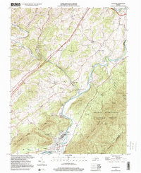
1999 Map of Glasgow
USGS Topo · Published 2000About this map
Glasgow sits at the southern confluence of the Maury River and the James River, serving as a central hub for the transport corridors that define this portion of Rockbridge County. The landscape is dominated by the ridges of Sallings Mountain and the Three Sisters Knobs, where the Appalachian Trail winds through the George Washington National Forest. Along the water, industry and commerce are evidenced by the historical footprint of Buffalo Forge and Buffalo Forge Station, alongside numerous quarries and the local Sewage Disposal infrastructure. Local genealogy is well-represented through a network of country churches, including Poplar Hill Ch, Elliotts Hill Ch, and Wesley Chapel. The rural character of the northern reaches is marked by small settlements like Mechanicsville and Buffalo Bend, connected by creeks such as Buffalo Creek and Broad Creek.
Find a feature on this map
43 named features on this map. Tap any name to fly to it.
Don’t see what you’re looking for? This feature index may not catch every label — zoom into the map to look around manually.
Map Details
Editions of this 1999 Glasgow Map
This is the sole edition of this map. No revisions or reprints were ever made.
Other maps of this area

1894 · Natural Bridge
USGS Topo · 1:125,000

1894 · Lexington
USGS Topo · 1:125,000

1894 · Natural Bridge
USGS Topo · 1:62,500

1907 · Natural Bridge Special
USGS Topo · 1:62,500

1932 · Lexington
USGS Topo · 1:48,000

1935 · Buena Vista
USGS Topo · 1:48,000

1937 · Lexington
USGS Topo · 1:62,500

1939 · Buena Vista
USGS Topo · 1:62,500

1940 · Buena Vista
USGS Topo · 1:62,500
1946 · Millboro
USGS Topo · 1:62,500