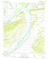
1961 Map of Gleason
USGS Topo · Published 1975About this map
The Arkansas River carves a sweeping path through this 1961 landscape, defining the boundaries of Faulkner, Conway, and Perry Counties. The Toad Suck Ferry provides a vital river crossing point near the community of Toad Suck, a location anchored by the nearby Bethel Ch. To the north, the Pacific railroad line runs parallel to Cadron Ridge and Cypress Creek, passing through the town of Gleason. This survey captures the rural character of the river valley before modern infrastructure changes, showing a network of small settlements like Nogal, Stony Point, and New Dixie. Family history is preserved at sites such as Casey Cem and Stony Point Cem, while the terrain is marked by significant heights including Jefferson Mountain and Toms Mountain.
Find a feature on this map
46 named features on this map. Tap any name to fly to it.
Don’t see what you’re looking for? This feature index may not catch every label — zoom into the map to look around manually.
Map Details
Editions of this 1961 Gleason Map
3 editions found

Other maps of this area

1890 · Benton
USGS Topo · 1:125,000

1891 · Little Rock
USGS Topo · 1:125,000

1892 · Morrillton
USGS Topo · 1:125,000

1893 · Little Rock
USGS Topo · 1:125,000

1894 · Morrillton
USGS Topo · 1:125,000

1894 · Benton
USGS Topo · 1:125,000

1953 · Mayflower
USGS Topo · 1:24,000

1955 · Little Rock
USGS Topo · 1:250,000

1956 · Little Rock
USGS Topo · 1:250,000

1956 · Russellville
USGS Topo · 1:250,000