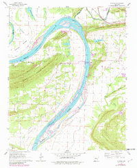
1961 Map of Gleason
USGS Topo · Published 1982About this map
Arkansas River bends sharply through this region, shaping a landscape defined by expansive floodplains like Portland Bottoms and the prominent elevations of Toms Mountain and Jefferson Mountain. This 1960s-era geography, with updates through the early 1980s, documents the critical river infrastructure at Toad Suck Ferry Lock & Dam and the Missouri Pacific railroad line skirting the northern ridge at Gleason. Smaller rural centers and crossroads like Nogal and Toad Suck are identified alongside several local congregations, including Pleasant Hill Ch and Bethel Ch. Genealogists may find value in the specific locations of Stony Point Cem and Casey Cem, while the industrial footprint is visible through the Waterworks and a Shale Pit located near Donald Ridge.
Find a feature on this map
40 named features on this map. Tap any name to fly to it.
Don’t see what you’re looking for? This feature index may not catch every label — zoom into the map to look around manually.
Map Details
Editions of this 1961 Gleason Map
3 editions found

Other maps of this area

1890 · Benton
USGS Topo · 1:125,000

1891 · Little Rock
USGS Topo · 1:125,000

1892 · Morrillton
USGS Topo · 1:125,000

1893 · Little Rock
USGS Topo · 1:125,000

1894 · Morrillton
USGS Topo · 1:125,000

1894 · Benton
USGS Topo · 1:125,000

1953 · Mayflower
USGS Topo · 1:24,000

1955 · Little Rock
USGS Topo · 1:250,000

1956 · Little Rock
USGS Topo · 1:250,000

1956 · Russellville
USGS Topo · 1:250,000