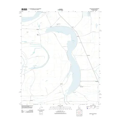
2012 Map of Glen Allan
USGS Topo · Published 2012About this map
Lake Washington dominates this Delta landscape, its distinct oxbow shape serving as a central landmark for the surrounding community. To the south, the settlement of Glen Allan anchors a network of rural roads such as Quong Rd and Ross-Winn Rd, while smaller locales like Alhambra and Erwin line the eastern shore. The geography is defined by its relationship to the water, from the massive Mississippi River and the Kentucky Bend Revetment in the northwest to the interior basins of Lake Jackson and Lake Britton. Genealogists can find the Metcalfe Cem near Chatham, providing a specific point of reference for local family history research. Transport patterns in the area are shaped by both the winding Levee Rd and local aviation via the Lake Washington Airport and Lewis Airport, illustrating the blend of traditional river defenses and modern accessibility in Washington County.
Find a feature on this map
52 named features on this map. Tap any name to fly to it.
Don’t see what you’re looking for? This feature index may not catch every label — zoom into the map to look around manually.
Map Details
Editions of this 2012 Glen Allan Map
This is the sole edition of this map. No revisions or reprints were ever made.
Other maps of this area

1909 · Wilsons Point
USGS Topo · 1:24,000

1909 · Millikin
USGS Topo · 1:24,000

1913 · Wilson Point
USGS Topo · 1:31,680

1939 · Lorenzen
USGS Topo · 1:62,500

1939 · Readland
USGS Topo · 1:62,500

1939 · Mayersville
USGS Topo · 1:62,500

1939 · Swan Lake
USGS Topo · 1:62,500

1953 · Greenwood
USGS Topo · 1:250,000

1955 · Jackson
USGS Topo · 1:250,000

1956 · Greenwood
USGS Topo · 1:250,000