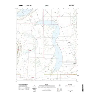
2020 Map of Glen Allan
USGS Topo · Published 2020About this map
Lake Washington, a massive oxbow lake of the Mississippi River, dominates this Mississippi Delta landscape, defining the layout of local settlements and agriculture. Along its northern curve, the community of Chatham sits near Byrne Lake and the Metcalfe Cem, while Erwin and Foote occupy the eastern shore. This 2020 map reflects a region deeply shaped by its alluvial history, where the wide, fertile spaces between the Mississippi River and Steele Bayou are organized by long-standing plantation and farming boundaries. To the south, the village of Glen Allan stands near the junction of Washington Bayou, which drains the southern end of the oxbow. Smaller communities like Marathon and Hampton are situated along the drainage of Steele Bayou, while the western edge of the quadrangle shows the river's border with Arkansas, including the distinct Kentucky Bend Bar.
Find a feature on this map
63 named features on this map. Tap any name to fly to it.
Don’t see what you’re looking for? This feature index may not catch every label — zoom into the map to look around manually.
Map Details
Editions of this 2020 Glen Allan Map
This is the sole edition of this map. No revisions or reprints were ever made.
Other maps of this area

1909 · Wilsons Point
USGS Topo · 1:24,000

1909 · Millikin
USGS Topo · 1:24,000

1913 · Wilson Point
USGS Topo · 1:31,680

1939 · Lorenzen
USGS Topo · 1:62,500

1939 · Readland
USGS Topo · 1:62,500

1939 · Mayersville
USGS Topo · 1:62,500

1939 · Swan Lake
USGS Topo · 1:62,500

1953 · Greenwood
USGS Topo · 1:250,000

1955 · Jackson
USGS Topo · 1:250,000

1956 · Greenwood
USGS Topo · 1:250,000