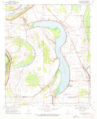
1970 Map of Glen Allan
USGS Topo · Published 1972About this map
The sweeping oxbow of Lake Washington dominates this 1970 landscape, illustrating the dynamic hydrology of the Mississippi Delta. In the community of Glen Allan, the presence of a Water Tank and several landing strips like Cypress Gardens Landing Strip point to an agricultural economy heavily reliant on aerial crop management and local infrastructure. To the north, the Mississippi River creates the boundary at Kentucky Bend Bar, while the interior is dotted with historical markers of settlement including Magnolia Ch Cem and Guiding Star Ch Cem. The eastern edge is preserved by the Yazoo National Wildlife Refuge, which borders ancient Indian Mounds, suggesting a deep timeline of human habitation along these alluvial banks. The network of bayous, such as Washington Bayou and Steele Bayou Road, defines the transport and drainage patterns essential to this riverfront region.
Find a feature on this map
38 named features on this map. Tap any name to fly to it.
Don’t see what you’re looking for? This feature index may not catch every label — zoom into the map to look around manually.
Map Details
Editions of this 1970 Glen Allan Map
This is the sole edition of this map. No revisions or reprints were ever made.
Other maps of this area

1909 · Wilsons Point
USGS Topo · 1:24,000

1909 · Millikin
USGS Topo · 1:24,000

1913 · Wilson Point
USGS Topo · 1:31,680

1939 · Lorenzen
USGS Topo · 1:62,500

1939 · Readland
USGS Topo · 1:62,500

1939 · Mayersville
USGS Topo · 1:62,500

1939 · Swan Lake
USGS Topo · 1:62,500

1953 · Greenwood
USGS Topo · 1:250,000

1955 · Jackson
USGS Topo · 1:250,000

1956 · Greenwood
USGS Topo · 1:250,000