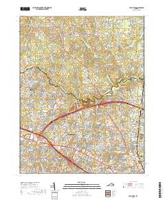
2019 Map of Glen Allen
USGS Topo · Published 2019About this map
The Chickahominy River carves a winding boundary between Hanover and Henrico counties, anchoring a landscape that bridges historical rural settlements and modern suburban growth. In the north, Farrington and Kenwood sit near the quiet waters of Stony Run and Grassy Swamp Cr, while the southern half of the map reveals the dense commercial and residential development of Short Pump and the corporate hub at Innsbrook. The area is rich with institutional history, evidenced by the Henrico County Courthouse and numerous long-standing religious sites such as Winns Ch, Springfield Church, and Mount Vernon Baptist Church. Genealogists may find value in the many burial grounds documented here, including Roselawn Memory Gardens, Shady Grove Cem, and Deep Run Cem. The terrain is characterized by numerous small tributaries like Deep Run and Hungary Cr that feed into the larger river system, punctuated by water bodies such as Overhill Lake and Hoehns Lake.
Find a feature on this map
304 named features on this map. Tap any name to fly to it.
Don’t see what you’re looking for? This feature index may not catch every label — zoom into the map to look around manually.
Map Details
Editions of this 2019 Glen Allen Map
This is the sole edition of this map. No revisions or reprints were ever made.
Other maps of this area

1890 · Goochland
USGS Topo · 1:125,000

1892 · Goochland
USGS Topo · 1:125,000

1894 · Richmond
USGS Topo · 1:62,500

1895 · Richmond
USGS Topo · 1:62,500

1918 · Doswell
USGS Topo · 1:62,500

1934 · Richmond
USGS Topo · 1:24,000

1936 · Richmond West
USGS Topo · 1:24,000

1936 · Glen Allen
USGS Topo · 1:24,000

1938 · Yellow Tavern
USGS Topo · 1:31,680

1939 · Richmond
USGS Topo · 1:31,680