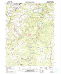
1993 Map of Glen Richey
USGS Topo · Published 1994About this map
The winding course of Clearfield Creek and the West Branch Susquehanna River anchor this central Pennsylvania landscape during the early 1990s. The terrain is characterized by high ridges like Clover Hill and narrow passages such as The Narrows, where infrastructure and industry follow the natural contours of the land. Evidence of the region’s coal mining history is visible in several Strip Mines and the presence of an Old Railroad Grade that once connected these extraction points to larger markets.
Find a feature on this map
58 named features on this map. Tap any name to fly to it.
Don’t see what you’re looking for? This feature index may not catch every label — zoom into the map to look around manually.
Map Details
Editions of this 1993 Glen Richey Map
This is the sole edition of this map. No revisions or reprints were ever made.
Other maps of this area

1903 · Curwensville
USGS Topo · 1:62,500

1903 · Houtzdale
USGS Topo · 1:62,500

1905 · Houtzdale
USGS Topo · 1:62,500

1929 · Clearfield
USGS Topo · 1:48,000

1929 · Penfield
USGS Topo · 1:62,500

1932 · Clearfield
USGS Topo · 1:62,500

1932 · Penfield
USGS Topo · 1:62,500

1939 · Curwensville
USGS Topo · 1:62,500

1942 · Curwensville
USGS Topo · 1:62,500

1943 · Punxsutawney
USGS Topo · 1:125,000