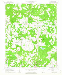
1962 Map of Glendale
USGS Topo · Published 1963About this map
The hills of Shawnee National Forest define the landscape of Pope and Johnson Counties in the early 1960s. The community of Glendale serves as a central point, situated near the Dixon Springs Experiment Station and the recreational waters of Lake Glendale. The presence of the Illinois Central railroad and an Old Railroad Grade near Grantsburg illustrates the shifting transportation patterns of southern Illinois, where rail lines once cut through the timbered ridges.
Find a feature on this map
44 named features on this map. Tap any name to fly to it.
Don’t see what you’re looking for? This feature index may not catch every label — zoom into the map to look around manually.
Map Details
Editions of this 1962 Glendale Map
This is the sole edition of this map. No revisions or reprints were ever made.
Other maps of this area

1917 · Brownfield
USGS Topo · 1:62,500

1918 · Vienna
USGS Topo · 1:62,500

1919 · Vienna
USGS Topo · 1:62,500

1925 · Marion
USGS Topo · 1:62,500

1925 · Harrisburg
USGS Topo · 1:62,500

1939 · Harrisburg
USGS Topo · 1:62,500

1940 · Marion
USGS Topo · 1:62,500

1942 · Vienna
USGS Topo · 1:62,500

1949 · Paducah
USGS Topo · 1:250,000

1950 · Paducah
USGS Topo · 1:250,000