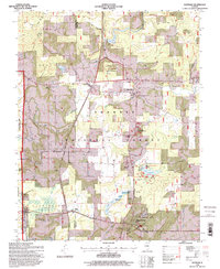
1996 Map of Glendale
USGS Topo · Published 1998About this map
Shawnee National Forest encompasses the majority of this landscape in the mid-1990s, where the rugged terrain of the Illinois Ozarks meets significant prehistoric and historical sites. At the Millstone Bluff National Register Site, the topography rises sharply to a prehistoric bluff-top settlement. To the south, the water-focused recreation at Lake Glendale is detailed alongside the Dixon Springs State Park and the nearby Dixon Springs Experiment Station. The map illustrates a rural social fabric maintained by family-named landmarks like Harper Cem and Kerley Cem, and small community centers at Simpson, Robbs, and Glendale. In the western portion, the State Prison Farm (Vienna Branch) occupies a large footprint, while Trigg Lookout on Johnson Ridge stands as a sentinel over the heavily forested creek valleys.
Find a feature on this map
47 named features on this map. Tap any name to fly to it.
Don’t see what you’re looking for? This feature index may not catch every label — zoom into the map to look around manually.
Map Details
Editions of this 1996 Glendale Map
This is the sole edition of this map. No revisions or reprints were ever made.
Other maps of this area

1917 · Brownfield
USGS Topo · 1:62,500

1918 · Vienna
USGS Topo · 1:62,500

1919 · Vienna
USGS Topo · 1:62,500

1925 · Marion
USGS Topo · 1:62,500

1925 · Harrisburg
USGS Topo · 1:62,500

1939 · Harrisburg
USGS Topo · 1:62,500

1940 · Marion
USGS Topo · 1:62,500

1942 · Vienna
USGS Topo · 1:62,500

1949 · Paducah
USGS Topo · 1:250,000

1950 · Paducah
USGS Topo · 1:250,000