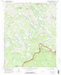
1967 Map of Glendale Springs
USGS Topo · Published 1979About this map
Glendale Springs serves as a central point of settlement on this 1967 survey of the High Country, where the Blue Ridge Parkway snakes through the southern landscape. The terrain is defined by the winding course of the South Fork New River, which creates a complex series of bends and ridges. Small community centers and rural hubs are marked by a high concentration of local houses of worship, including Calvary Ch, Holy Trinity Ch, and Riverview Ch, indicating a closely-knit social fabric typical of these mountain townships.
Find a feature on this map
52 named features on this map. Tap any name to fly to it.
Don’t see what you’re looking for? This feature index may not catch every label — zoom into the map to look around manually.
Map Details
Editions of this 1967 Glendale Springs Map
3 editions found
Other maps of this area

1889 · Wilkesboro
USGS Topo · 1:125,000

1891 · Wilkesboro
USGS Topo · 1:125,000

1893 · Cranberry
USGS Topo · 1:125,000

1895 · Cranberry
USGS Topo · 1:125,000

1899 · Cranberry
USGS Topo · 1:125,000

1902 · Cranberry
USGS Topo · 1:125,000

1936 · Blowing Rock
USGS Topo · 1:48,000

1942 · Blowing Rock
USGS Topo · 1:62,500

1953 · Winston-Salem
USGS Topo · 1:250,000

1955 · Winston-Salem
USGS Topo · 1:250,000