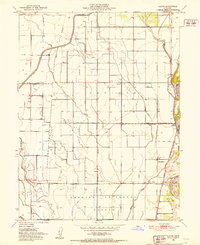
1951 Map of Glenn
USGS Topo · Published 1953About this map
The Sacramento River defines the eastern boundary of this agricultural landscape in the early 1950s, a period when complex irrigation and flood control systems were central to the region's productivity. The map details a network of vital waterways including the Main Canal, Colusa Canal, and Provident Canal, interspersed with levee systems and numerous siphons. The Southern Pacific railroad line runs parallel to the river, serving local shipping points like Glenn Siding and the settlement of Glenn.
Find a feature on this map
28 named features on this map. Tap any name to fly to it.
Don’t see what you’re looking for? This feature index may not catch every label — zoom into the map to look around manually.
Map Details
Editions of this 1951 Glenn Map
3 editions found
Historical Maps of Glenn Through Time
90 maps found

1904 Logan Creek
Glenn County, CA

1904 Walker Creek
Glenn County, CA

1912 Butte City
Glenn County, CA

1914 Hamilton
Glenn County, CA

1917 Jacinto
Glenn County, CA

1917 Kurand
Glenn County, CA

1917 Logandale
Glenn County, CA

1917 Lyman
Glenn County, CA

1918 Logan Creek
Glenn County, CA

1919 Fruto
Glenn County, CA

1944 Fruto
Glenn County, CA

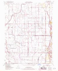
1951 Glenn
Glenn County, CA

1952 Butte City
Glenn County, CA

1952 Fruto NE
Glenn County, CA

1952 Hull Mountain
Glenn County, CA

1952 Logandale
Glenn County, CA

1952 Stone Valley
Glenn County, CA

1958 Fruto
Glenn County, CA

1958 Logan Ridge
Glenn County, CA

1967 Alder Springs
Glenn County, CA

1967 Plaskett meadows
Glenn County, CA

1968 Chrome
Glenn County, CA

1968 Felkner Hill
Glenn County, CA

1968 Fruto
Glenn County, CA

1968 Julian Rocks
Glenn County, CA

1968 St. John Mtn.
Glenn County, CA

1989 Rail Canyon
Glenn County, CA

1995 Chrome
Glenn County, CA

1995 Plaskett Meadows
Glenn County, CA

1996 Alder Springs
Glenn County, CA

1996 Felkner Hill
Glenn County, CA

1996 St. John Mountain
Glenn County, CA

2012 Alder Springs
Glenn County, CA

2012 Butte City
Glenn County, CA

2012 Chrome
Glenn County, CA

2012 Felkner Hill
Glenn County, CA

2012 Fruto
Glenn County, CA

2012 Fruto NE
Glenn County, CA

2012 Glenn
Glenn County, CA

2012 Julian Rocks
Glenn County, CA

2012 Logandale
Glenn County, CA

2012 Logan Ridge
Glenn County, CA

2012 Plaskett Meadows
Glenn County, CA

2012 Rail Canyon
Glenn County, CA

2012 Saint John Mountain
Glenn County, CA

2012 Stone Valley
Glenn County, CA

2015 Alder Springs
Glenn County, CA

2015 Butte City
Glenn County, CA

2015 Chrome
Glenn County, CA

2015 Felkner Hill
Glenn County, CA

2015 Fruto
Glenn County, CA

2015 Fruto NE
Glenn County, CA

2015 Glenn
Glenn County, CA

2015 Julian Rocks
Glenn County, CA

2015 Logandale
Glenn County, CA

2015 Logan Ridge
Glenn County, CA

2015 Plaskett Meadows
Glenn County, CA

2015 Rail Canyon
Glenn County, CA

2015 Saint John Mountain
Glenn County, CA

2015 Stone Valley
Glenn County, CA

2018 Alder Springs
Glenn County, CA

2018 Butte City
Glenn County, CA

2018 Chrome
Glenn County, CA

2018 Felkner Hill
Glenn County, CA

2018 Fruto
Glenn County, CA

2018 Fruto NE
Glenn County, CA

2018 Glenn
Glenn County, CA

2018 Julian Rocks
Glenn County, CA

2018 Logandale
Glenn County, CA

2018 Logan Ridge
Glenn County, CA

2018 Plaskett Meadows
Glenn County, CA

2018 Rail Canyon
Glenn County, CA

2018 Saint John Mountain
Glenn County, CA

2018 Stone Valley
Glenn County, CA

2021 Alder Springs
Glenn County, CA

2021 Butte City
Glenn County, CA

2021 Chrome
Glenn County, CA

2021 Felkner Hill
Glenn County, CA

2021 Fruto
Glenn County, CA

2021 Fruto NE
Glenn County, CA

2021 Glenn
Glenn County, CA

2021 Julian Rocks
Glenn County, CA

2021 Logan Ridge
Glenn County, CA

2021 Plaskett Meadows
Glenn County, CA

2021 Rail Canyon
Glenn County, CA

2021 Stone Valley
Glenn County, CA

2022 Logandale
Glenn County, CA

2022 Saint John Mountain
Glenn County, CA

2023 Fruto
Glenn County, CA

2023 Rail Canyon
Glenn County, CA