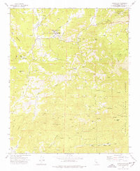
1972 Map of Glennville
USGS Topo · Published 1977About this map
Glennville sits at the heart of this Kern County landscape, where the Linn Valley transition from ranch lands to the high peaks of the Sequoia National Forest is clearly visible. The area is defined by the headwaters of the White Poso River and Poso Creek, which feed smaller reservoirs such as Lake Marion and Lake Stockton. For local historians, the map documents significant landmarks including the Glennville Adobe and the Oak Grove Cemetery, alongside rural infrastructure like the Linn Valley School and the landing strip. To the east and south, the terrain becomes increasingly complex around Fulton Peak and Basket Peak, where a network of trails and jeep tracks connects remote points like Basket Pass and Lackey Place. The presence of a Substation and Diversion Dam underscores the management of water and power in this foothills environment during the early 1970s.
Find a feature on this map
48 named features on this map. Tap any name to fly to it.
Don’t see what you’re looking for? This feature index may not catch every label — zoom into the map to look around manually.
Map Details
Editions of this 1972 Glennville Map
2 editions found
Other maps of this area

1920 · Delonagha
USGS Topo · 1:62,500

1926 · Glennville
USGS Topo · 1:62,500

1932 · Woody
USGS Topo · 1:62,500

1935 · Woody
USGS Topo · 1:62,500

1936 · White River
USGS Topo · 1:62,500

1936 · Tobias Peak
USGS Topo · 1:125,000

1943 · Tobias Peak
USGS Topo · 1:125,000

1945 · Tobias Peak
USGS Topo · 1:62,500

1948 · Bakersfield
USGS Topo · 1:250,000
1952 · Woody
USGS Topo · 1:62,500