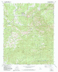
1972 Map of Glennville
USGS Topo · Published 1994About this map
Glennville sits at the heart of Linns Valley in this detailed look at Kern County ranching country during the early 1970s. The settlement's history is anchored by the Glennville Adobe and the nearby Oak Grove Cem, providing clear evidence of early California high-country habitation. The landscape transitions from the residential and agricultural activity around Linns Valley Sch to the steep eastern slopes of the Sequoia National Forest.
Find a feature on this map
49 named features on this map. Tap any name to fly to it.
Don’t see what you’re looking for? This feature index may not catch every label — zoom into the map to look around manually.
Map Details
Editions of this 1972 Glennville Map
2 editions found
Other maps of this area

1920 · Delonagha
USGS Topo · 1:62,500

1926 · Glennville
USGS Topo · 1:62,500

1932 · Woody
USGS Topo · 1:62,500

1935 · Woody
USGS Topo · 1:62,500

1936 · White River
USGS Topo · 1:62,500

1936 · Tobias Peak
USGS Topo · 1:125,000

1943 · Tobias Peak
USGS Topo · 1:125,000

1945 · Tobias Peak
USGS Topo · 1:62,500

1948 · Bakersfield
USGS Topo · 1:250,000
1952 · Woody
USGS Topo · 1:62,500