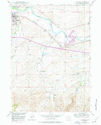
1949 Map of Glenrock
USGS Topo · Published 1977About this map
H A Unthank Grave and an Oregon Trail Marker sit south of the North Platte River, marking the deep historical tracks through this portion of Wyoming. The landscape near Glenrock reflects a mix of early pioneer history and mid-century industrial development, with a Powerplant and a Cable Ferry situated along the river banks. Farther south, the terrain rises into the foothills of the Laramie Range, where the Converse County Park and Brighton Cave offer a look at the area's natural landmarks and recreation spaces before modern expansion.
Find a feature on this map
41 named features on this map. Tap any name to fly to it.
Don’t see what you’re looking for? This feature index may not catch every label — zoom into the map to look around manually.
Map Details
Editions of this 1949 Glenrock Map
2 editions found
Other maps of this area

1949 · Careyhurst
USGS Topo · 1:24,000

1949 · Parkerton
USGS Topo · 1:24,000

1949 · Glenrock
USGS Topo · 1:24,000

1949 · Leuenberger Ranch
USGS Topo · 1:24,000

1949 · Glenrock NW
USGS Topo · 1:24,000

1949 · Hylton Ranch
USGS Topo · 1:24,000

1950 · Careyhurst
USGS Topo · 1:24,000

1950 · Leuenberger Ranch
USGS Topo · 1:24,000

1950 · Parkerton
USGS Topo · 1:24,000

1950 · Glenrock NW
USGS Topo · 1:24,000