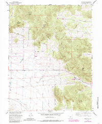
1956 Map of Glentivar
USGS Topo · Published 1985About this map
Glentivar marks a specific point of historical interest on this mid-century survey of the high-altitude landscape of Park County. The terrain is defined by the steep elevation changes of the Puma Hills, where peaks like Schoolmarm Mountain and Badger Mountain dominate the eastern half of the map. Transport and passage are dictated by the natural gaps in these ranges, most notably at Wilkerson Pass, which features a dedicated Visitor Center, and the more remote La Salle Pass.
Find a feature on this map
32 named features on this map. Tap any name to fly to it.
Don’t see what you’re looking for? This feature index may not catch every label — zoom into the map to look around manually.
Map Details
Editions of this 1956 Glentivar Map
5 editions found

Other maps of this area

1893 · Platte Canyon
USGS Topo · 1:125,000

1894 · Pikes Peak
USGS Topo · 1:125,000

1901 · Pikes Peak
USGS Topo · 1:125,000

1953 · Denver
USGS Topo · 1:250,000

1954 · Pueblo
USGS Topo · 1:250,000

1956 · Eagle Rock
USGS Topo · 1:24,000

1956 · Mc Curdy Mountain
USGS Topo · 1:24,000

1956 · Tarryall
USGS Topo · 1:24,000

1956 · Sulphur Mountain
USGS Topo · 1:24,000

1956 · Elevenmile Canyon
USGS Topo · 1:24,000