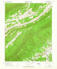
1963 Map of Glenvar
USGS Topo · Published 1965About this map
Fort Lewis Mountain and Catawba Mountain dominate this corner of the Commonwealth, where the Appalachian Trail winds through the Jefferson National Forest and Havens State Game Refuge. In the lower valleys, the Norfolk and Western railway follows the course of the Roanoke River, connecting the settlements of Glenvar and Wabun. The map documents a rural landscape defined by family-named landmarks and ridge-top topography, featuring numerous small burial grounds such as Beard Cem, Brillheart Cem, and Custer Cem. To the northwest, the small community of Bradshaw sits along Bradshaw Creek, while the higher elevations are marked by lookout and radio towers. This 1960s survey preserves the mid-century layout of local landmarks like the Wesleyan Chapel and Ft Lewis Ch before modern development altered the Roanoke County corridors.
Find a feature on this map
48 named features on this map. Tap any name to fly to it.
Don’t see what you’re looking for? This feature index may not catch every label — zoom into the map to look around manually.
Map Details
Editions of this 1963 Glenvar Map
4 editions found
Other maps of this area

1890 · Christiansburg
USGS Topo · 1:125,000

1923 · Waiteville
USGS Topo · 1:62,500

1929 · Salem
USGS Topo · 1:48,000

1931 · Waiteville
USGS Topo · 1:48,000

1932 · Salem
USGS Topo · 1:62,500

1932 · Blacksburg
USGS Topo · 1:48,000

1937 · Blacksburg
USGS Topo · 1:62,500

1944 · Waiteville
USGS Topo · 1:62,500

1950 · Elliston
USGS Topo · 1:62,500

1951 · Waiteville
USGS Topo · 1:62,500