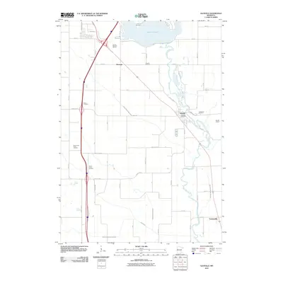
2010 Map of Glenville
USGS Topo · Published 2010About this map
Glenville and its surrounding agricultural landscape are defined by the winding course of the Shell Rock River, which flows southward toward the community of Gordonsville. This 2010 survey reveals a rural Minnesota terrain meticulously managed through a network of drainage systems, including County Ditch Number Sixteen and County Ditch Number Seventy-six, which support the vast farmland between the river and Albert Lea Lake. For genealogists and local historians, the area is notable for its numerous burial grounds, such as Green Cemetery, Round Prairie Cemetery, and the Greenwood Cemetery located just east of the village center near the Glenville Post Office. The infrastructure of the era is marked by the presence of the Air-AG Airport and several localized road networks, including Margaretha Ave and Alcia Ln, which connect the scattered homesteads and the small settlement of Murtaugh to the regional hubs.
Find a feature on this map
44 named features on this map. Tap any name to fly to it.
Don’t see what you’re looking for? This feature index may not catch every label — zoom into the map to look around manually.
Map Details
Editions of this 2010 Glenville Map
This is the sole edition of this map. No revisions or reprints were ever made.
Other maps of this area

1954 · Albert Lea
USGS Topo · 1:62,500

1954 · Hayward
USGS Topo · 1:62,500

1954 · Mason City
USGS Topo · 1:250,000

1957 · Mason City
USGS Topo · 1:250,000

1958 · Mason City
USGS Topo · 1:250,000

1972 · Northwood
USGS Topo · 1:24,000

1972 · Fertile NE
USGS Topo · 1:24,000

1972 · Bristol
USGS Topo · 1:24,000

1982 · Hayward
USGS Topo · 1:24,000

1982 · Albert Lea West
USGS Topo · 1:24,000
Featured Places
- Albert Lea, MN
- Glenville, MN
- Stoney Creek Estates, Albert Lea
- Rainbow Terrace Mobile Home Park, Albert Lea
- Murtaugh, MN