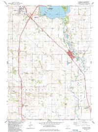
1982 Map of Glenville
USGS Topo · Published 1983About this map
The Shell Rock River winds through this Freeborn County landscape, anchoring the settlement of Glenville at its bend. This 1980s-era documentation shows a region defined by its water and transport, where Albert Lea Lake and the Helmer Myre State Park dominate the northern terrain. The infrastructure reflects a heavy reliance on the rail corridor, with the Chicago Illinois and Central Gulf and North Western lines crossing the prairie. Local history is deeply embedded in the rural corners, from the North Round Prairie Cem and Round Prairie Ch in the west to the small siding at Murtaugh and the southernmost village of Gordonsville. Numerous gravel pits along the river suggest the local extractive industries that shaped the area's development alongside its agricultural roots.
Find a feature on this map
31 named features on this map. Tap any name to fly to it.
Don’t see what you’re looking for? This feature index may not catch every label — zoom into the map to look around manually.
Map Details
Editions of this 1982 Glenville Map
This is the sole edition of this map. No revisions or reprints were ever made.
Other maps of this area

1954 · Albert Lea
USGS Topo · 1:62,500

1954 · Hayward
USGS Topo · 1:62,500

1954 · Mason City
USGS Topo · 1:250,000

1957 · Mason City
USGS Topo · 1:250,000

1958 · Mason City
USGS Topo · 1:250,000

1972 · Northwood
USGS Topo · 1:24,000

1972 · Fertile NE
USGS Topo · 1:24,000

1972 · Bristol
USGS Topo · 1:24,000

1982 · Hayward
USGS Topo · 1:24,000

1982 · Albert Lea West
USGS Topo · 1:24,000