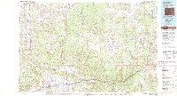
1981 Map of Glenwood Springs
USGS Topo · Published 1982About this map
The Grand Hogback and Roan Cliffs dominate this 1981 survey, defining a landscape shaped by energy development and transport corridors along the Colorado River. This era shows the extensive Naval Oil Shale Reserve and industrial sites like the Anvil Points Oil Shale Mine, reflecting a period of intense focus on local geological resources. To the east, the confluence of the Roaring Fork River and the Colorado at Glenwood Springs marks a major regional hub, served by the Denver and Rio Grande Western railroad.
Find a feature on this map
50 named features on this map. Tap any name to fly to it.
Don’t see what you’re looking for? This feature index may not catch every label — zoom into the map to look around manually.
Map Details
Editions of this 1981 Glenwood Springs Map
2 editions found
Other maps of this area

1906 · Grand Hogback
USGS Topo · 1:125,000

1907 · White River
USGS Topo · 1:125,000

1909 · Mount Jackson
USGS Topo · 1:125,000

1910 · Danforth Hills
USGS Topo · 1:125,000

1910 · Grand Hogback
USGS Topo · 1:125,000

1910 · White River
USGS Topo · 1:125,000

1911 · Mount Jackson
USGS Topo · 1:125,000

1912 · Meeker
USGS Topo · 1:62,500

1914 · Meeker
USGS Topo · 1:62,500

1925 · Parachute Creek
USGS Topo · 1:62,500