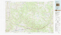
1981 Map of Glenwood Springs
USGS Topo · Published 1982About this map
The Colorado River corridor defines the southern half of this landscape, serving as the primary artery for both transportation and industry in the early 1980s. Along this route, the Denver and Rio Grande Western railroad tracks and Interstate 70 connect settlements such as Rifle, New Castle, and Glenwood Springs. A significant portion of the western terrain is dedicated to energy resources, specifically within the Naval Oil Shale Reserve and the Anvil Points Oil Shale Mines near the Roan Cliffs. To the north, the elevation rises sharply toward the White River Plateau and the White River National Forest, where the terrain is dominated by high mesas like Clinetop Mesa and Coulter Mesa. This transition from the industrial river valley to the protected wilderness of the White River headwaters illustrates the dual nature of the region's economy and geography.
Find a feature on this map
44 named features on this map. Tap any name to fly to it.
Don’t see what you’re looking for? This feature index may not catch every label — zoom into the map to look around manually.
Map Details
Editions of this 1981 Glenwood Springs Map
2 editions found
Other maps of this area

1906 · Grand Hogback
USGS Topo · 1:125,000

1907 · White River
USGS Topo · 1:125,000

1909 · Mount Jackson
USGS Topo · 1:125,000

1910 · Danforth Hills
USGS Topo · 1:125,000

1910 · Grand Hogback
USGS Topo · 1:125,000

1910 · White River
USGS Topo · 1:125,000

1911 · Mount Jackson
USGS Topo · 1:125,000

1912 · Meeker
USGS Topo · 1:62,500

1914 · Meeker
USGS Topo · 1:62,500

1925 · Parachute Creek
USGS Topo · 1:62,500