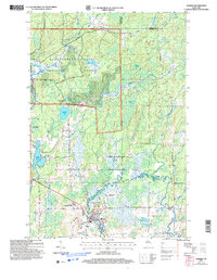
2005 Map of Glidden
USGS Topo · Published 2006About this map
The Glidden settlement and its surrounding north-woods landscape are defined by a complex watershed where the Great Divide separates northward-flowing waters like the Bad River from the southern drainages of the East Fork Chippewa River. Situated within the Chequamegon-Nicolet National Forest, this area reveals a mid-century logging and resource extraction legacy through numerous Gravel Pits and forest service routes like Ranger District Road and Old Morse Road. Genealogists will find the Mt Hope Cem located just north of the town center, while local history is marked by landmarks like Marian Park and the Great Divide Wayside Park. The landscape is dotted with numerous small bodies of water, including Gordon Lake, Summit Lake, and Dry Lake, which reflect the glacial character of this portion of Ashland County.
Find a feature on this map
40 named features on this map. Tap any name to fly to it.
Don’t see what you’re looking for? This feature index may not catch every label — zoom into the map to look around manually.
Map Details
Editions of this 2005 Glidden Map
This is the sole edition of this map. No revisions or reprints were ever made.
Other maps of this area

1940 · Butternut
USGS Topo · 1:48,000

1940 · Upson
USGS Topo · 1:48,000

1942 · Glidden
USGS Topo · 1:48,000

1942 · Mellen
USGS Topo · 1:48,000

1943 · Upson
USGS Topo · 1:48,000

1945 · Glidden
USGS Topo · 1:48,000

1945 · Mellen
USGS Topo · 1:48,000

1947 · Butternut
USGS Topo · 1:48,000

1950 · Butternut
USGS Topo · 1:48,000

1953 · Ashland
USGS Topo · 1:250,000