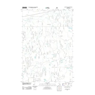
2011 Map of Glitter Lake
USGS Topo · Published 2011About this map
Haystack Mountain rises above the winding East Branch Ontonagon River in this detailed survey of Houghton County. The landscape is defined by a dense network of forest service roads and water bodies, including the centrally located Beitner Lake and Three-On Lake. Near the northern boundary, Kitchie Cemetery and the route of Old Hwy M-28 offer specific points of interest for genealogists and local historians tracking early settlement and infrastructure in Michigan’s Upper Peninsula. To the south, the presence of the Tepee Lookout Tower and Lower Dam Lake Campground highlights the area's legacy of forest management and outdoor recreation. The map meticulously documents the numerous creeks feeding the river system, such as Stony Creek and Glitter Creek, providing a comprehensive view of the local drainage and topography in the early twenty-first century.
Find a feature on this map
38 named features on this map. Tap any name to fly to it.
Don’t see what you’re looking for? This feature index may not catch every label — zoom into the map to look around manually.
Map Details
Editions of this 2011 Glitter Lake Map
This is the sole edition of this map. No revisions or reprints were ever made.
Other maps of this area

1895 · Perch Lake
USGS Topo · 1:62,500

1954 · Rousseau
USGS Topo · 1:62,500

1954 · Kenton
USGS Topo · 1:62,500

1954 · Perch Lake
USGS Topo · 1:62,500

1954 · Sidnaw
USGS Topo · 1:62,500

1958 · Iron River
USGS Topo · 1:250,000

1960 · Iron River
USGS Topo · 1:250,000

1961 · Iron River
USGS Topo · 1:250,000

1967 · Iron River
USGS Topo · 1:250,000
1982 · Sparrow Rapids
USGS Topo · 1:25,000