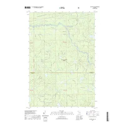
2019 Map of Glitter Lake
USGS Topo · Published 2019About this map
Ottawa National Forest dominates this portion of the Upper Peninsula, where the Ontonagon Wild and Scenic River and its various branches, including the Branch Ontonagon River and E Br Ontonagon River, carve through the timberland. The landscape is a complex network of glacial lakes and wetlands, including the eponymous Glitter Lake, Beitner Lake, and Muffle Lake. Human presence is concentrated along the northern corridor where Kitchie Rd and Old Hwy M-28 parallel the historic route of the Bessemer Snowmobile #8 (Snow) trail.
Find a feature on this map
97 named features on this map. Tap any name to fly to it.
Don’t see what you’re looking for? This feature index may not catch every label — zoom into the map to look around manually.
Map Details
Editions of this 2019 Glitter Lake Map
This is the sole edition of this map. No revisions or reprints were ever made.
Other maps of this area

1895 · Perch Lake
USGS Topo · 1:62,500

1954 · Rousseau
USGS Topo · 1:62,500

1954 · Kenton
USGS Topo · 1:62,500

1954 · Perch Lake
USGS Topo · 1:62,500

1954 · Sidnaw
USGS Topo · 1:62,500

1958 · Iron River
USGS Topo · 1:250,000

1960 · Iron River
USGS Topo · 1:250,000

1961 · Iron River
USGS Topo · 1:250,000

1967 · Iron River
USGS Topo · 1:250,000
1982 · Sparrow Rapids
USGS Topo · 1:25,000