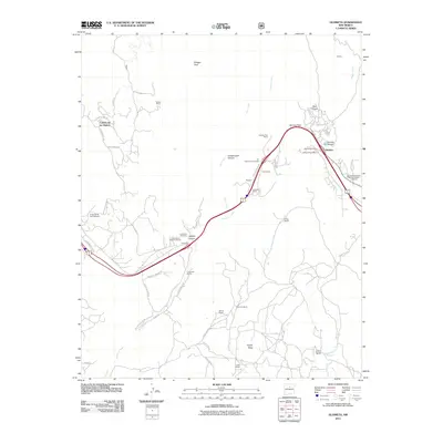
2011 Map of Glorieta
USGS Topo · Published 2011About this map
Glorieta Pass and the surrounding terrain of the Sangre de Cristo foothills dominate this 2011 survey, which documents the complex geography of a critical transit corridor. The map highlights the Glorieta Battlefield National Historic Landmark, a site of significant American Civil War history where a pivotal conflict occurred in 1862. Modern transportation routes follow ancient paths, with the Cañoncito Siding and interstate corridors threading through Apache Canyon. Small settlements and family holdings like Cañoncito at Apache Canyon, Gonzales Ranch, and El Rancho de San Sebastian are interspersed among the rugged drainages of Galisteo Creek and Glorieta Creek. For genealogists and local historians, the inclusion of Cañoncito Cemetery and Glorieta Cemetery, along with several remote ranching outposts like Ortiga Ranch, provides a detailed look at the rural land use and community structure at the start of the 21st century.
Find a feature on this map
53 named features on this map. Tap any name to fly to it.
Don’t see what you’re looking for? This feature index may not catch every label — zoom into the map to look around manually.
Map Details
Editions of this 2011 Glorieta Map
This is the sole edition of this map. No revisions or reprints were ever made.
Other maps of this area

1889 · Santa Fe
USGS Topo · 1:125,000

1894 · Santa Fe
USGS Topo · 1:125,000

1894 · Lamy
USGS Topo · 1:125,000

1952 · Santa Fe
USGS Topo · 1:24,000

1952 · Seton Village
USGS Topo · 1:24,000

1953 · Glorieta
USGS Topo · 1:24,000

1953 · Mc Clure Reservoir
USGS Topo · 1:24,000

1954 · Santa Fe
USGS Topo · 1:250,000

1958 · Santa Fe
USGS Topo · 1:250,000
1961 · Santa Fe
USGS Topo · 1:24,000