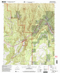
2002 Map of Glorieta
USGS Topo · Published 2003About this map
Glorieta Pass and the surrounding high country of the Santa Fe National Forest define this landscape, where the geography of the Sangre de Cristo Mountains dictates the flow of commerce and history. The map highlights the strategic importance of this corridor, anchored by the Glorieta Battlefield and the Pecos National Historic Park, where critical Civil War history is preserved. Settlements like Glorieta and Canoncito follow the rail and road lines through the pass, while the spiritual heritage of the region is centered at the Nuestra Senora de La Luz Church, a designated National Historic Landmark.
Find a feature on this map
37 named features on this map. Tap any name to fly to it.
Don’t see what you’re looking for? This feature index may not catch every label — zoom into the map to look around manually.
Map Details
Editions of this 2002 Glorieta Map
This is the sole edition of this map. No revisions or reprints were ever made.
Other maps of this area

1889 · Santa Fe
USGS Topo · 1:125,000

1894 · Santa Fe
USGS Topo · 1:125,000

1894 · Lamy
USGS Topo · 1:125,000

1952 · Santa Fe
USGS Topo · 1:24,000

1952 · Seton Village
USGS Topo · 1:24,000

1953 · Glorieta
USGS Topo · 1:24,000

1953 · Mc Clure Reservoir
USGS Topo · 1:24,000

1954 · Santa Fe
USGS Topo · 1:250,000

1958 · Santa Fe
USGS Topo · 1:250,000
1961 · Santa Fe
USGS Topo · 1:24,000