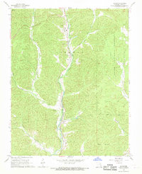
1968 Map of Glover
USGS Topo · Published 1969About this map
Big Creek winds through the heart of this Iron County landscape, anchoring a valley where the Missouri Pacific railroad facilitated local industry. In the late 1960s, the community of Glover was notably defined by its Lead Smelter and associated infrastructure, including a prominent Water Tank. This industrial presence contrasts with the surrounding expanse of the Clark National Forest, which covers much of the high ground including Vickery Mountain and Grassy Mountain. Small settlements like Chloride and Sabula appear along the rail line and creek, serving as focal points for rural life. For genealogists, the map is a vital resource, plotting several family and community burial sites such as Huff Cem, Hurst Cem, and the combined church and burial ground at Emilys Chapel Cem. The terrain is deeply etched by a network of drainage including Little Creek and Richland Creek, while a Cave and various Jeep Trails suggest the localized geography of the Ozarks.
Find a feature on this map
27 named features on this map. Tap any name to fly to it.
Don’t see what you’re looking for? This feature index may not catch every label — zoom into the map to look around manually.
Map Details
Editions of this 1968 Glover Map
This is the sole edition of this map. No revisions or reprints were ever made.
Other maps of this area

1924 · Edgehill
USGS Topo · 1:62,500

1926 · Edgehill
USGS Topo · 1:62,500

1926 · Des Arc
USGS Topo · 1:62,500

1929 · Des Arc
USGS Topo · 1:62,500

1937 · Ironton
USGS Topo · 1:48,000

1943 · Lesterville
USGS Topo · 1:62,500

1945 · Ironton
USGS Topo · 1:62,500

1946 · Lesterville
USGS Topo · 1:62,500

1946 · Ironton
USGS Topo · 1:62,500

1949 · Rolla
USGS Topo · 1:250,000