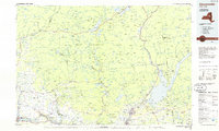
1985 Map of Gloversville
USGS Topo · Published 1986About this map
Adirondack Park dominates the northern half of this landscape, where the rugged southern reaches of the mountains meet the industrial corridors of the Mohawk Valley. The topography is defined by significant water bodies such as Great Sacandaga Lake, Piseco Lake, and Peck Lake, which have long served as centers for recreation and local settlement. These high-country lakes give way to the West Branch Sacandaga River and East Canada Creek, following the natural drainage south toward the transportation arteries of the Mohawk River.
Find a feature on this map
340 named features on this map. Tap any name to fly to it.
Don’t see what you’re looking for? This feature index may not catch every label — zoom into the map to look around manually.
Map Details
Editions of this 1985 Gloversville Map
2 editions found
Other maps of this area

1893 · Schenectady
USGS Topo · 1:62,500

1895 · North Creek
USGS Topo · 1:62,500

1895 · Schenectady
USGS Topo · 1:62,500

1895 · Amsterdam
USGS Topo · 1:62,500

1896 · Fonda
USGS Topo · 1:62,500

1897 · North Creek
USGS Topo · 1:62,500

1897 · Remsen
USGS Topo · 1:62,500

1898 · Schenectady
USGS Topo · 1:62,500

1898 · Fonda
USGS Topo · 1:62,500

1898 · Thirteenth Lake
USGS Topo · 1:62,500