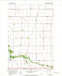
1964 Map of Glyndon North
USGS Topo · Published 1966About this map
The Buffalo River meanders across the southern landscape of this mid-1960s survey, providing a sharp contrast to the rigid, geometric grid of the surrounding agricultural townships. This area of Clay County is defined by its sophisticated water management system, illustrated by an extensive network of drainage channels such as County Ditch No 39 and County Ditch No 25, which enabled the cultivation of the fertile Red River Valley. The Great Northern railroad cuts a straight diagonal line through the townships of Morken and Spring Prairie, serving the grain-handling needs of rural hubs like Averill. Near the settlement of Glyndon, the Riverside Cem sits along the riverbanks, offering a point of interest for genealogists. The map also identifies local civic structures, including a Townhall situated at a crossroads in the eastern section.
Find a feature on this map
19 named features on this map. Tap any name to fly to it.
Don’t see what you’re looking for? This feature index may not catch every label — zoom into the map to look around manually.
Map Details
Editions of this 1964 Glyndon North Map
2 editions found
Other maps of this area

1895 · Fargo
USGS Topo · 1:125,000

1897 · Fargo
USGS Topo · 1:125,000

1918 · Ulen
USGS Topo · 1:62,500

1919 · Hawley
USGS Topo · 1:62,500

1952 · Grand Forks
USGS Topo · 1:250,000

1953 · Fargo
USGS Topo · 1:250,000

1956 · Fargo
USGS Topo · 1:250,000

1956 · Grand Forks
USGS Topo · 1:250,000

1964 · Sabin
USGS Topo · 1:24,000

1964 · Dilworth
USGS Topo · 1:24,000