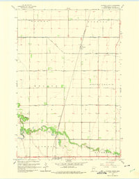
1964 Map of Glyndon North
USGS Topo · Published 1975About this map
The Great Northern railroad corridor dictates the settlement pattern of this Clay County landscape, where the iron road cuts a straight line through the townships of Morken and Moland. Near the southern edge, the village of Glyndon serves as a local hub, while the smaller siding of Averill sits further north along the tracks. This mid-century survey captures a highly engineered agricultural environment, defined by a rigid grid of drainage projects including County Ditch No 39 and County Ditch No 25.
Find a feature on this map
19 named features on this map. Tap any name to fly to it.
Don’t see what you’re looking for? This feature index may not catch every label — zoom into the map to look around manually.
Map Details
Editions of this 1964 Glyndon North Map
2 editions found
Other maps of this area

1895 · Fargo
USGS Topo · 1:125,000

1897 · Fargo
USGS Topo · 1:125,000

1918 · Ulen
USGS Topo · 1:62,500

1919 · Hawley
USGS Topo · 1:62,500

1952 · Grand Forks
USGS Topo · 1:250,000

1953 · Fargo
USGS Topo · 1:250,000

1956 · Fargo
USGS Topo · 1:250,000

1956 · Grand Forks
USGS Topo · 1:250,000

1964 · Sabin
USGS Topo · 1:24,000

1964 · Dilworth
USGS Topo · 1:24,000