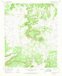
1957 Map of Goat Mountain
USGS Topo · Published 1968About this map
Uranium mining operations define the high desert industry of this 1957 McKinley County landscape, as seen in the clustered workings of the Homestake-Sapin Mine No 15, Kermac Mine No 10, and Silver Spur Mine. This era of mineral extraction is set against a backdrop of traditional land use, where established holdings like Berryhill Ranch and Navarre Ranch sit near massive geologic landmarks. The terrain is dominated by prominent mesas and buttes, including the centrally located Mesa Redonda and the southern Mesa Montanosa. A specialized Airstrip (Private) near Loma de la Gloria highlights the logistical needs of these remote operations. From the deep Rincón Canyon to the heights of Goat Mountain, the map documents a transition point where ancient landforms became the site of mid-century industrial expansion.
Find a feature on this map
21 named features on this map. Tap any name to fly to it.
Don’t see what you’re looking for? This feature index may not catch every label — zoom into the map to look around manually.
Map Details
Editions of this 1957 Goat Mountain Map

Other maps of this area

1883 · Mt. Taylor
USGS Topo · 1:250,000

1886 · Wingate
USGS Topo · 1:250,000

1886 · Mt. Taylor
USGS Topo · 1:250,000

1892 · Wingate
USGS Topo · 1:250,000

1892 · Mt. Taylor
USGS Topo · 1:250,000

1899 · Mt. Taylor
USGS Topo · 1:250,000

1954 · Gallup
USGS Topo · 1:250,000

1957 · Ambrosia Lake
USGS Topo · 1:24,000

1957 · Dos Lomas
USGS Topo · 1:24,000

1957 · Bluewater
USGS Topo · 1:24,000