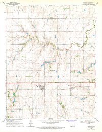
1965 Map of Goddard
USGS Topo · Published 1966About this map
Goddard sits at the center of this mid-1960s landscape, serving as a hub for the surrounding townships of Attica, Garden Plain, and Afton. The village is clearly defined by its street grid and proximity to the Atchison Topeka and Santa Fe railroad, which cuts a straight line through the southern half of the map. To the north, the small settlement of St Marks is anchored by a Water Tank, while the wider countryside is dotted with local heritage sites like Pleasant Ridge Cem and Church Camp. The topography is marked by the winding paths of Dry Creek and Afton Creek, which drain toward the reservoir at Lake Afton County Park in the southwest corner. This survey captures a moment of agricultural stability just as utility infrastructure, noted by a prominent Pipeline and Sewage Disposal site, began to expand.
Find a feature on this map
19 named features on this map. Tap any name to fly to it.
Don’t see what you’re looking for? This feature index may not catch every label — zoom into the map to look around manually.
Map Details
Editions of this 1965 Goddard Map
2 editions found
Other maps of this area

1889 · Cheney
USGS Topo · 1:125,000

1889 · Wichita
USGS Topo · 1:125,000

1891 · Cheney
USGS Topo · 1:125,000

1894 · Wichita
USGS Topo · 1:125,000

1901 · Cheney
USGS Topo · 1:125,000

1941 · Maize
USGS Topo · 1:31,680

1942 · Maize
USGS Topo · 1:31,680

1943 · Wichita West
USGS Topo · 1:31,680

1943 · Bayneville
USGS Topo · 1:31,680

1950 · Bayneville
USGS Topo · 1:24,000