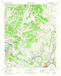
1965 Map of Godwin
USGS Topo · Published 1967About this map
Duck River winds through the heart of Maury County, defining a landscape of sharp limestone bluffs and deep alluvial bends during the mid-1960s. The region north of Columbia is characterized by a dense network of country roads and family-named hollows, such as Taylor Hollow and Watson Hollow, which speak to generations of local settlement. This period shows the transition from rural agriculture to early suburban expansion, evidenced by the emergence of residential clusters like Royal Oaks and Hardy Acres near the northern edge of the city.
Find a feature on this map
90 named features on this map. Tap any name to fly to it.
Don’t see what you’re looking for? This feature index may not catch every label — zoom into the map to look around manually.
Map Details
Editions of this 1965 Godwin Map
3 editions found
Other maps of this area

1901 · Colombia
USGS Topo · 1:125,000

1909 · Franklin
USGS Topo · 1:62,500

1936 · Godwin
USGS Topo · 1:24,000

1936 · Williamsport
USGS Topo · 1:24,000

1936 · Primm
USGS Topo · 1:24,000

1936 · Spring Hill
USGS Topo · 1:24,000

1936 · Theta
USGS Topo · 1:24,000

1936 · Carters Creek
USGS Topo · 1:24,000

1936 · Mount Pleasant
USGS Topo · 1:24,000

1936 · Glendale
USGS Topo · 1:24,000